Foundation soil data for every US county
USDA's soil survey rates two soil problems for houses: clay that shrinks and swells under slabs and footings, and water tables shallow enough to reach basements. Here is where each one sits, next to this week's drought map, flood losses since 2016 and the age of the homes.
3,144 counties · 1,227 Texas cities · 922 Ohio cities · drought map of November 3, 2026
of mapped US land: shrink-swell clay limits houses without basements
of mapped US land: a shallow water table limits basements
of US homes were built before 1980 (ACS 2020-2024)
counties and county-equivalents, each with its own page
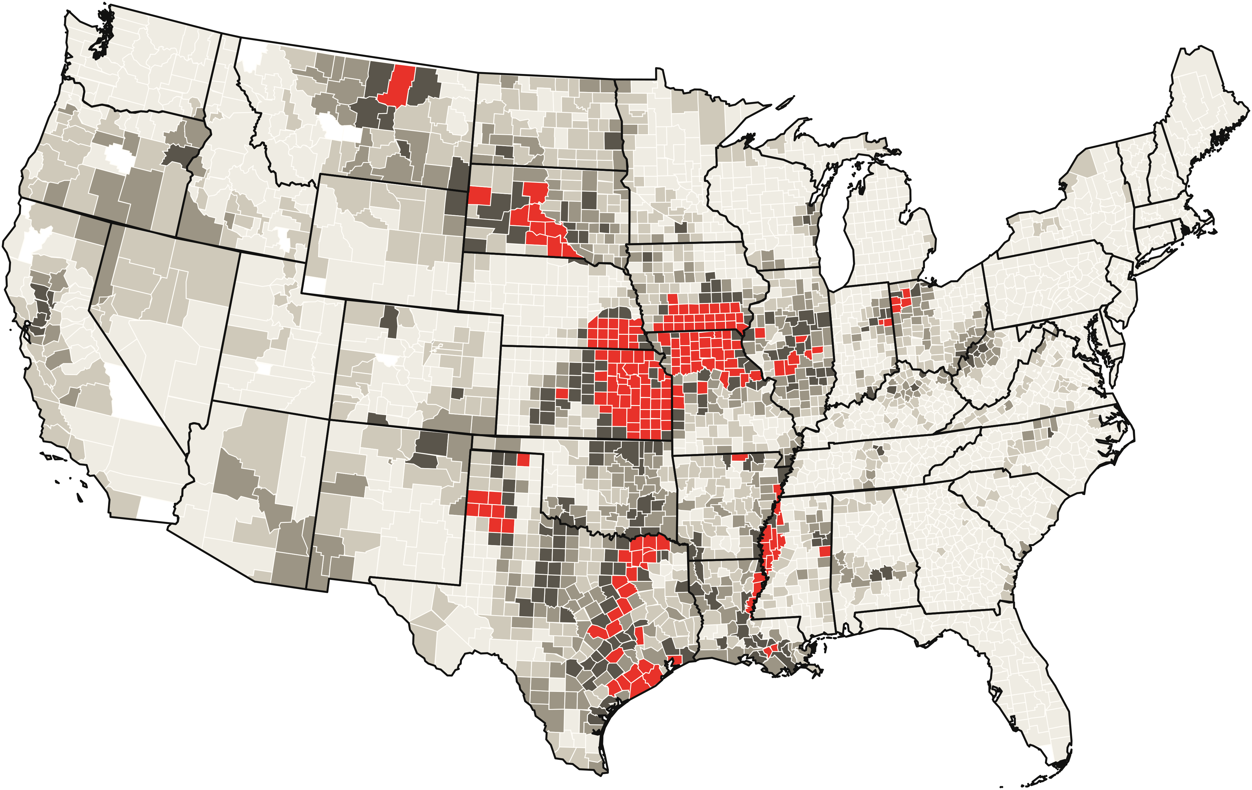
Where the clay is
Counties with the largest share of mapped land where shrink-swell clay limits houses without basements.
| County | Expansive clay |
|---|---|
| Jones County, SD | 94% |
| Fillmore County, NE | 91% |
| Adair County, IA | 91% |
| Audrain County, MO | 90% |
| Lyman County, SD | 89% |
| Stanley County, SD | 89% |
| Haakon County, SD | 89% |
| Adams County, IA | 88% |
| Madison County, IA | 88% |
| Shelby County, MO | 87% |
Clay counties in drought this week
Clay shrinks as it dries. These counties have the most land that is both shrink-swell clay and in drought on the November 3, 2026 Drought Monitor map (clay share times drought share).
| County | Clay land in drought |
|---|---|
| Humphreys County, MS | 86% |
| Audrain County, MO | 86% |
| Floyd County, TX | 84% |
| Sharkey County, MS | 79% |
| Hunt County, TX | 78% |
| Delta County, TX | 77% |
| Sunflower County, MS | 76% |
| Navarro County, TX | 75% |
| Tensas Parish, LA | 75% |
| Kaufman County, TX | 73% |
Every expansive clay county, week by week: the drought watch.
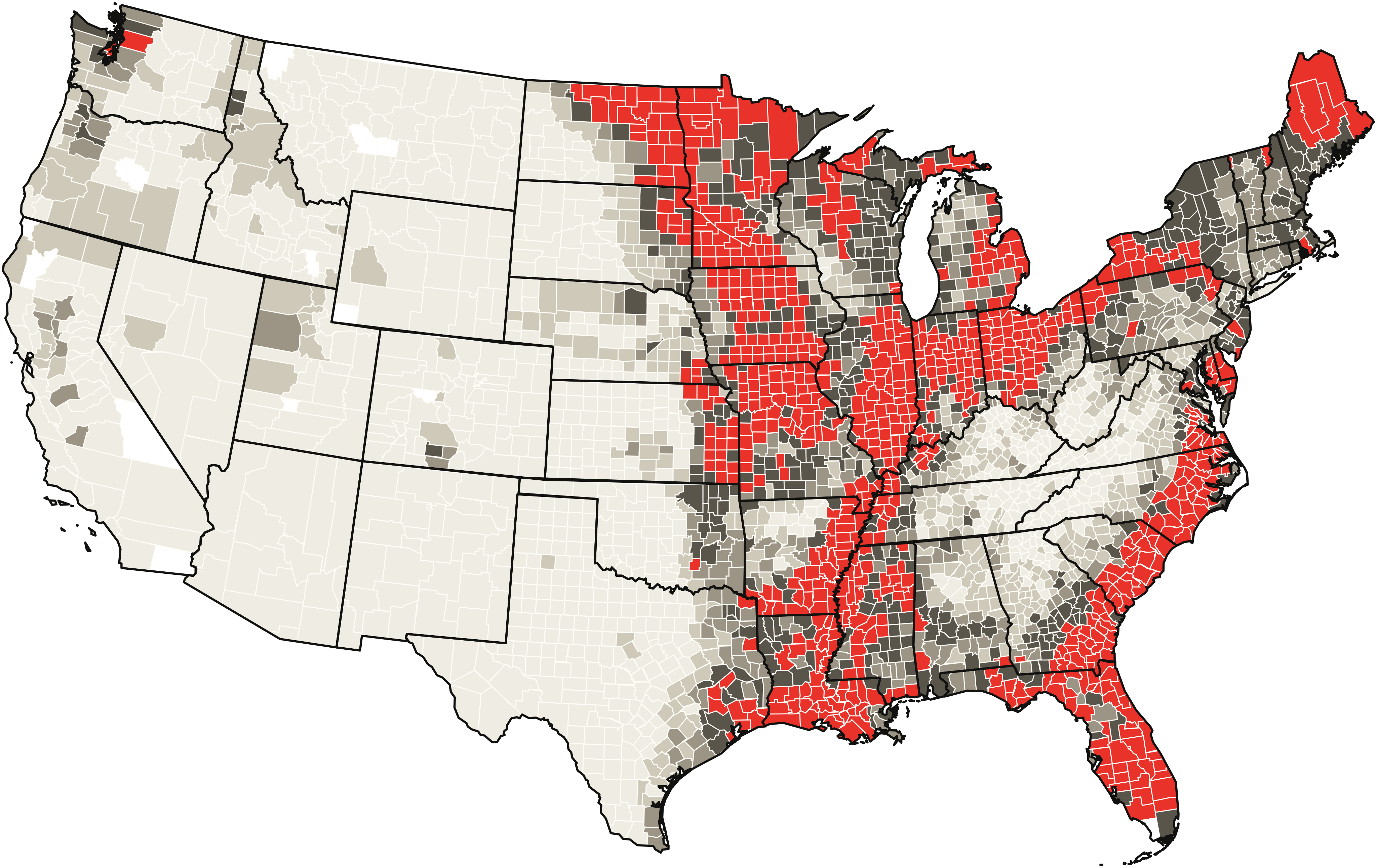
Where the water table is shallow
Counties with the largest share of mapped land where a shallow water table limits basements.
| County | High water table |
|---|---|
| Clinch County, GA | over 99% |
| DeSoto County, FL | 99% |
| Linn County, MO | 99% |
| Baker County, FL | 99% |
| Hardee County, FL | 99% |
| Van Wert County, OH | 99% |
| Berkeley County, SC | 99% |
| Hampton County, SC | 99% |
| Charlton County, GA | 99% |
| Williamsburg County, SC | 99% |
Texas and Ohio cities
Every incorporated city in both states has its own page, measured inside city limits. Largest shares among cities with 5,000+ homes:
| Texas city | Expansive clay |
|---|---|
| Plainview | 91% |
| Bay City | 88% |
| Royse City | 87% |
| Ennis | 86% |
| Converse | 85% |
| Manor | 84% |
| Forney | 83% |
| Rockwall | 83% |
| Princeton | 83% |
| Taylor | 81% |
| Ohio city | High water table |
|---|---|
| Washington Court House | 96% |
| Pataskala | 95% |
| Avon Lake | 94% |
| Wilmington | 93% |
| Greenville | 92% |
| Willowick | 91% |
| Aurora | 89% |
| Brunswick | 89% |
| Hilliard | 88% |
| North Ridgeville | 87% |
Largest Texas cities
All Texas counties and cities · All Ohio counties and cities
Every state
- Alabama 10% clay · 32% water
- Alaska under 1% clay · 51% water
- Arizona 13% clay · under 1% water
- Arkansas 23% clay · 48% water
- California 13% clay · 7% water
- Colorado 12% clay · 4% water
- Connecticut under 1% clay · 37% water
- Delaware under 1% clay · 59% water
- District of Columbia 0% clay · 9% water
- Florida 2% clay · 70% water
- Georgia 3% clay · 40% water
- Hawaii 5% clay · 5% water
- Idaho 9% clay · 8% water
- Illinois 31% clay · 70% water
- Indiana 12% clay · 66% water
- Iowa 32% clay · 61% water
- Kansas 41% clay · 19% water
- Kentucky 9% clay · 21% water
- Louisiana 31% clay · 67% water
- Maine under 1% clay · 62% water
- Maryland 1% clay · 45% water
- Massachusetts under 1% clay · 41% water
- Michigan 3% clay · 54% water
- Minnesota 9% clay · 68% water
- Mississippi 19% clay · 60% water
- Missouri 38% clay · 59% water
- Montana 23% clay · 3% water
- Nebraska 14% clay · 15% water
- Nevada 12% clay · 5% water
- New Hampshire 2% clay · 39% water
- New Jersey under 1% clay · 46% water
- New Mexico 14% clay · 1% water
- New York 3% clay · 49% water
- North Carolina 5% clay · 43% water
- North Dakota 19% clay · 40% water
- Ohio 19% clay · 65% water
- Oklahoma 26% clay · 17% water
- Oregon 20% clay · 11% water
- Pennsylvania 1% clay · 44% water
- Rhode Island 0% clay · 42% water
- South Carolina 4% clay · 54% water
- South Dakota 38% clay · 18% water
- Tennessee 5% clay · 24% water
- Texas 28% clay · 10% water
- Utah 4% clay · 9% water
- Vermont 1% clay · 42% water
- Virginia 6% clay · 25% water
- Washington 2% clay · 14% water
- West Virginia 11% clay · 13% water
- Wisconsin 7% clay · 46% water
- Wyoming 12% clay · 3% water
Calculators
Guides
- Crawl space encapsulation updated September 2026
- Crawl space encapsulation cost updated October 2026
- Basement flooding updated September 2026
- Wet basements updated September 2026
- Crawl space moisture and humidity updated October 2026
- Foundation watering updated September 2026
- Signs of foundation problems updated September 2026
- Foundation crack repair updated September 2026
- Foundation drains updated October 2026
- Foundation inspection cost updated September 2026
- Pier-and-beam foundation repair cost updated October 2026
- Foundation repair cost updated October 2026
- Basement waterproofing cost updated September 2026
- Sinking foundation and house settling updated October 2026
- Sump pump cost updated October 2026
- What soil is my house built on? updated October 2026
- How to tell if your house is on expansive clay updated October 2026
- Soil test before building a house updated November 2026
How this site works
Every number comes from public data: USDA's soil survey (SSURGO), the US Drought Monitor, FEMA's flood records, NOAA rainfall and the Census Bureau's housing survey. Scripts pull and check them, and every page shows its sources and dates. Sources and methods · Data status · How we get paid.